![]()
| Tornado's power, path rare for
Md.
Winds reached 180 mph in storm's 10-mile trail, weather service says; 'Not all that common here'; Cyclone might prove to be most expensive that ever hit state By Frank D. Roylance Sun Staff Originally published September 26, 2001 Tornadoes occur somewhere in Maryland nearly every year.
But few have had the power to pick up automobiles and cause the deaths,
injuries and destruction seen from College Park to Laurel on Monday.
Copyright © 2001, The Baltimore
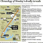
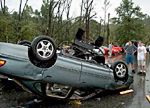
Sun"I was impressed by the continued strength of the tornado over a long track. That's not all that common around here," said Barbara Watson, warning coordinator for the National Weather Service's forecast office in Sterling, Va. Watson flew over the storm's 10-mile track in Maryland yesterday with the Maryland State Police. "I was just trying to think, how are we going to count all these buildings - businesses, homes, churches, schools - and thousands and thousands of trees?" she said. "I was just impressed with the scope of it all." Watson rated the storm a "solid" F3 on the seven-tier Fujita scale, with top winds of 170 to 180 mph. It was neither the deadliest tornado to strike Maryland nor the most powerful. But it might have been the costliest. Maryland's worst tornado struck a schoolhouse in La Plata, in Charles County, on Nov. 9, 1926. It killed 14 children, then moved into Prince George's County and killed three more people. That storm is estimated to have been an F4 storm, packing winds between 206 and 260 mph and capable of leveling houses and hurling cars through the air. The only other F4 storm ever recorded in Maryland was a tornado that struck near Frostburg, in Allegany County, on June 2, 1998. More than 100 homes and businesses were damaged or destroyed. Damages were estimated at $5 million. There were no deaths and only five injuries. Until Monday, the costliest tornado in Maryland history was the Reisterstown storm Oct. 18, 1990. The F2 tornado struck an apartment complex, tearing off the roof and injuring 59. Damages were estimated then at $9.5 million. "My guess is that [Monday's storm] would be more," Watson said yesterday. "All that public, private and federal property; it's gonna be impressive." In all, from 1756 through June of this year, tornadoes in what is now the Sterling forecast area - from Allegany County east to the Chesapeake Bay - have killed at least 55 people and injured 268 more. Property damages have been estimated - without adjusting for inflation - at more than $48 million. Harold E. Brooks, a research meteorologist at the National Severe Storms Center in Norman, Okla., said the central part of Maryland - from the mountains to the upper Eastern Shore -seems to lie in an area of heightened vulnerability to strong tornadoes compared with places to the north and south. "Exactly why is a good question," Brooks said. Tornadoes form when cool, dry air moving from one direction collides with warm, moist air moving from another, triggering violent updrafts and a whirling vortex of wind. The high terrain of West Virginia, he said, might provide added cooling and drying to air moving into the region from the northwest, increasing the contrasts with warm air blowing in from the Atlantic and boosting the tornado risk. Monday's storm was first spotted at 4 p.m. by weather service employees manning the Doppler radar at the forecast office in Sterling. Winds near Stafford, Va., had begun a characteristic slow, counter-clockwise rotation, said meteorologist Christopher A. Strong. "We had a very strong front coming through with a big low-pressure area developing in the Great Lakes area," he said. That cold front was moving over a mass of warm, moist air blowing in from the southeast, creating ideal conditions for a tornado to form. At 4:09 p.m., Sterling issued its first tornado warning, alerting residents of northern Stafford and eastern Prince William counties that a tornado had formed in the area. Tornado watches had been in effect since 1:31 p.m. across most of Maryland and eastern Virginia. After the storm formed, it seemed to follow U.S. 1 northward over Virginia toward Washington, strengthening and weakening, but causing relatively little damage. At 4:53 p.m., the weather service issued a warning for eastern Fairfax County, Alexandria, and metropolitan Washington. "It weakened as it was going into Fairfax, and we were thinking it might fall apart," Strong said. At 5:03 p.m., "the funnel cloud was sighted from the Pentagon and also by an observer at National Airport." But as it moved toward the northeastern corner of the District, it became more menacing. "It really started to strengthen quite a bit and turned into a pretty impressive storm," Strong said. At 5:10 p.m., the weather service issued a tornado warning for Prince George's County - about 10 minutes before it struck the University of Maryland campus. "That was common with this storm," Strong said. "The warnings were issued with about 10 minutes of lead time." Watson said the storm left an unbroken trail of destruction in Maryland 10 miles long. For most of that distance, the funnel was just 150 yards wide on the ground - about average. "My gosh, if it had been wider, it would have been much worse," she said. Some large tornadoes have been as much as a mile in diameter. The chain of wreckage began a mile or two southwest of College Park and led to a demolished townhouse development in the Howard County section of Laurel. Watson and weather service meteorologist Jim Travers toured the damage in Maryland yesterday and used what they saw in College Park to assign the storm its F3 rating. "The thing that Barbara saw that moved it into the F3 category was a parking lot where there were several hundred cars. These things were picked up and thrown around like toys, and piled on top of trees beyond the parking lot," Travers said. The damage north of College Park was more characteristic of an F2 storm, he said. |
|